
Heatwave in U.S. East as 2024 summer begins
Heatwave in U.S. East! It's scorching the eastern half of the U.S. as summer sets in. More on the heatwave and a new heat risk map, here.
The post Heatwave in U.S. East as 2024 summer begins first appeared on EarthSky.
Heatwave in U.S. East
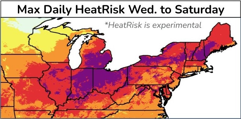
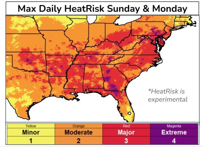
With the arrival of summer in the Northern Hemisphere comes the first significant heatwave of the season for those in the U.S. East. The U.S. Great Lakes and New England are seeing their hottest temperatures of the year so far on Wednesday and Thursday, June 19 and 20, 2024. The Ohio Valley and Mid-Atlantic should expect their highest temperatures on Friday and Saturday, June 21 and 22. And then the heat shifts southeast from Sunday to Monday, June 23 and 24.
The National Weather Service said on June 19:
A heat wave will continue to impact areas from the Midwest into much of the Ohio Valley, Great Lakes, Northeast and Mid-Atlantic through the next few days. Afternoon high temperatures and warm overnight lows will likely challenge daily records and even some monthly records. Heat index readings are expected to peak from 100 to 105 degrees in many locations.
Those without access to reliable air conditioning are urged to find a way to cool down. Record warm overnight temperatures will prevent natural cooling and allow the heat danger to build over time indoors without air conditioning.
Conditions are expected to improve over New England this weekend.
Heat risk
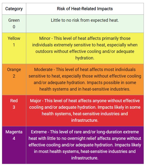
The National Weather Service is debuting a new product called a heat risk map. You can choose a day in the upcoming 7-day forecast and find a color-coded map showing how at risk your region is for heat impacts. The color-coded maps include stages zero through four.
The National Weather Service explains the heat risk map:
… provides a forecast risk of heat-related impacts to occur over a 24-hour period. HeatRisk takes into consideration:
- How unusual the heat is for the time of the year
- The duration of the heat including both daytime and nighttime temperatures
- If those temperatures pose an elevated risk of heat-related impacts based on data from the CDC
This index is supplementary to official NWS heat products and is meant to provide risk guidance for those decision makers and heat-sensitive populations who need to take actions at levels that may be below current NWS heat product levels.
Bottom line: A heatwave is scorching the eastern half of the U.S. as summer sets in. More on the heatwave and a new heat risk map, here.
The post Heatwave in U.S. East as 2024 summer begins first appeared on EarthSky.